
Make a donation
Gear up for your next adventure:
As an Amazon Associate, this site earns from qualifying purchases at no extra cost to you.
Ashoknagar Kalyangarh topographic map
Click on the map to display elevation.
Make a donation
Gear up for your next adventure:
As an Amazon Associate, this site earns from qualifying purchases at no extra cost to you.
Ashoknagar Kalyangarh
Ashoknagar is located at 22°49′59″N 88°37′59″E / 22.833°N 88.633°E / 22.833; 88.633. It is situated in the World's largest delta, The Ganga-Brahmaputra Delta. The elevation of Ashoknagar Kalyangarh from sea-level is 8 meters. There are many forest, several lakes, some canals and vast green fields in this area. Below the ground of Ashoknagar, there is a huge amount of petroleum (as the ONGC and The Union Minister of Petroleum and Natural Gas, Mr. Dharmendra Pradhan said).
Make a donation
Gear up for your next adventure:
As an Amazon Associate, this site earns from qualifying purchases at no extra cost to you.
About this map
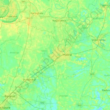
Name: Ashoknagar Kalyangarh topographic map, elevation, terrain.
Location: Ashoknagar Kalyangarh, Habra - II, West Bengal, 743222, India (22.67874 88.46460 22.99874 88.78460)
Average elevation: 23 ft
Minimum elevation: -7 ft
Maximum elevation: 56 ft
Make a donation
Gear up for your next adventure:
As an Amazon Associate, this site earns from qualifying purchases at no extra cost to you.