
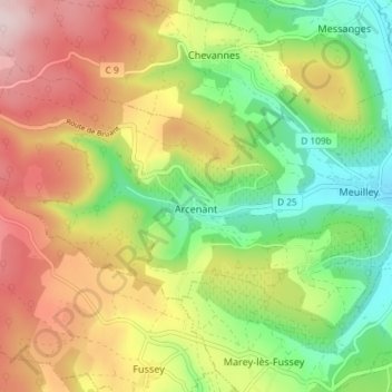
Arcenant topographic map
Interactive map
Click on the map to display elevation.
About this map
Name: Arcenant topographic map, elevation, terrain.
Average elevation: 1,430 ft
Minimum elevation: 915 ft
Maximum elevation: 2,047 ft
Other topographic maps
Click on a map to view its topography, its elevation and its terrain.
Mont Auxois
France > Bourgogne-Franche-Comté > Côte-d'Or > Alise-Sainte-Reine
Average elevation: 1,007 ft
La Verrerie
France > Bourgogne-Franche-Comté > Côte-d'Or > Velars-sur-Ouche
Average elevation: 1,152 ft
Auvillard
France > Bourgogne-Franche-Comté > Côte-d'Or > Saint-Victor-sur-Ouche
Average elevation: 1,437 ft
Point d’eau du Leuzeu
France > Bourgogne-Franche-Comté > Côte-d'Or > Flavignerot
Average elevation: 1,611 ft
Gouville
France > Bourgogne-Franche-Comté > Côte-d'Or > Corcelles-les-Monts
Average elevation: 1,280 ft
Au Faubourg
France > Bourgogne-Franche-Comté > Côte-d'Or > Flavigny-sur-Ozerain
Average elevation: 1,243 ft