
Penedones topographic map
Interactive map
Click on the map to display elevation.
About this map
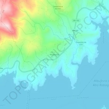
Name: Penedones topographic map, elevation, terrain.
Location: Penedones, Chã, Montalegre, Vila Real, 5470-071, Portugal (41.74286 -7.82909 41.78286 -7.78909)
Average elevation: 2,995 ft
Minimum elevation: 2,808 ft
Maximum elevation: 3,773 ft
Other topographic maps
Click on a map to view its topography, its elevation and its terrain.
Firvidas
Portugal > Vila Real > Montalegre > Chã
Firvidas, Chã, Montalegre, Vila Real, 5470-065, Portugal
Average elevation: 3,212 ft
Medeiros
Portugal > Vila Real > Montalegre > Chã
Medeiros, Chã, Montalegre, Vila Real, 5470-071, Portugal
Average elevation: 3,199 ft