
Thank you for supporting this site ❤️
Make a donation
Make a donation
Gear up for your next adventure:
As an Amazon Associate, this site earns from qualifying purchases at no extra cost to you.
Viaverde topographic map
Click on the map to display elevation.
Thank you for supporting this site ❤️
Make a donation
Make a donation
Gear up for your next adventure:
As an Amazon Associate, this site earns from qualifying purchases at no extra cost to you.
About this map
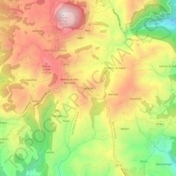
Name: Viaverde topographic map, elevation, terrain.
Location: Viaverde, Velo Veronese, Verona, Veneto, 37028, Italia (45.57644 11.08642 45.61644 11.12642)
Average elevation: 3,084 ft
Minimum elevation: 1,955 ft
Maximum elevation: 4,068 ft
Thank you for supporting this site ❤️
Make a donation
Make a donation
Gear up for your next adventure:
As an Amazon Associate, this site earns from qualifying purchases at no extra cost to you.