
Make a donation
Gear up for your next adventure:
As an Amazon Associate, this site earns from qualifying purchases at no extra cost to you.
Cleona topographic map
Click on the map to display elevation.
Make a donation
Gear up for your next adventure:
As an Amazon Associate, this site earns from qualifying purchases at no extra cost to you.
About this map
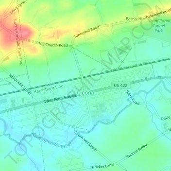
Name: Cleona topographic map, elevation, terrain.
Location: Cleona, Lebanon County, Pennsylvania, United States (40.33096 -76.48874 40.34581 -76.46115)
Average elevation: 479 ft
Minimum elevation: 407 ft
Maximum elevation: 646 ft
Lebanon County trails, hiking, mountain biking, running and outdoor activities
Make a donation
Gear up for your next adventure:
As an Amazon Associate, this site earns from qualifying purchases at no extra cost to you.
Other topographic maps
Click on a map to view its topography, its elevation and its terrain.
Weavertown
United States > Pennsylvania > Lebanon County > North Lebanon Township
Average elevation: 558 ft
Stricklerstown
United States > Pennsylvania > Lebanon County > Millcreek Township
Average elevation: 627 ft
Make a donation
Gear up for your next adventure:
As an Amazon Associate, this site earns from qualifying purchases at no extra cost to you.