Geolocate

Hosanagara topographic map

Click on the map to display elevation.

Hosanagara

Hosanagar is located at 13°55′N 75°04′E / 13.92°N 75.07°E / 13.92; 75.07. It has an average elevation of 585 metres (1919 feet).

About this map

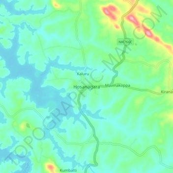
Name: Hosanagara topographic map, elevation, terrain.

Location: Hosanagara, Hosanagara taluk, Shimoga district, Karnataka, 577418, India (13.87679 75.02580 13.95679 75.10580)

Average elevation: 1,916 ft

Minimum elevation: 1,808 ft

Maximum elevation: 2,323 ft

Gear up for your next adventure:

🥩Freeze-Dried Meals - Nutritious and lightweight food for remote expeditions
🚪Portable Camp Chair - Foldable chair for comfort at camp
🦶Hiking Gaiters - Keep debris and water out of your boots
🛰️Satellite Messengers - Emergency SOS and two-way messaging for off-grid adventures
🛌Ultralight Sleeping Bags - Compact down bags for cold nights in the wilderness

As an Amazon Associate, this site earns from qualifying purchases at no extra cost to you.