Geolocate

Corydon topographic map

Click on the map to display elevation.

About this map

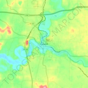
Name: Corydon topographic map, elevation, terrain.

Location: Corydon, Harrison County, Indiana, 471112, United States (38.17293 -86.16539 38.25293 -86.08539)

Average elevation: 663 ft

Minimum elevation: 502 ft

Maximum elevation: 928 ft

Harrison County trails, hiking, mountain biking, running and outdoor activities

Gear up for your next adventure:

🔭Compact Binoculars - HD vision for scouting terrain and identifying distant landmarks
🧣Merino Neck Gaiters - Multi-functional headwear for wind and sun protection
📦Gear Storage Bags - Organize and protect outdoor equipment
🔦LED Headlamp - Bright and durable LED headlamp for night navigation
🧥Men's Rain Shells - Premium waterproof and breathable jackets for mountain weather

As an Amazon Associate, this site earns from qualifying purchases at no extra cost to you.