
Make a donation
Gear up for your next adventure:
As an Amazon Associate, this site earns from qualifying purchases at no extra cost to you.
Friedrichshafen topographic map
Click on the map to display elevation.
Make a donation
Gear up for your next adventure:
As an Amazon Associate, this site earns from qualifying purchases at no extra cost to you.
Friedrichshafen
Friedrichshafen liegt an einer sanft geschwungenen Bucht am Nordufer des Bodensees und am Südwestrand des Schussenbeckens. Die Stadt erstreckt sich über eine Höhenlage von 395,2 m ü. NHN am Bodenseeufer bis 501,6 m in Ailingen (Horach). Die Kernstadt befindet sich unweit westlich der Mündung der Rotach in den Bodensee. Von Oberteuringen kommend erreicht dieser Fluss westlich der Ortschaft Ailingen das Stadtgebiet und durchfließt einige kleinere Ortsteile, bevor er am Ostrand der Kernstadt in den See mündet. Die etwas größere Schussen streift die nordöstliche Ecke des Stadtgebietes, bevor auch sie – wenige Kilometer östlich von Friedrichshafen – im Bodensee endet.
Make a donation
Gear up for your next adventure:
As an Amazon Associate, this site earns from qualifying purchases at no extra cost to you.
About this map
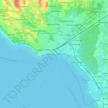
Name: Friedrichshafen topographic map, elevation, terrain.
Average elevation: 1,335 ft
Minimum elevation: 1,286 ft
Maximum elevation: 1,594 ft
Make a donation
Gear up for your next adventure:
As an Amazon Associate, this site earns from qualifying purchases at no extra cost to you.