
Make a donation
Gear up for your next adventure:
As an Amazon Associate, this site earns from qualifying purchases at no extra cost to you.
Holland topographic map
Click on the map to display elevation.
Make a donation
Gear up for your next adventure:
As an Amazon Associate, this site earns from qualifying purchases at no extra cost to you.
Holland
Holland is the highest town in Orleans County. Perhaps due to its high altitude, Holland has historically had the coolest weather and highest rate of snowfall in Orleans County.
Make a donation
Gear up for your next adventure:
As an Amazon Associate, this site earns from qualifying purchases at no extra cost to you.
About this map
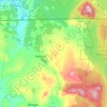
Name: Holland topographic map, elevation, terrain.
Location: Holland, Orleans County, Vermont, 05830, United States (44.93099 -72.06578 45.00837 -71.89931)
Average elevation: 1,545 ft
Minimum elevation: 1,027 ft
Maximum elevation: 2,421 ft
Orleans County trails, hiking, mountain biking, running and outdoor activities
Make a donation
Gear up for your next adventure:
As an Amazon Associate, this site earns from qualifying purchases at no extra cost to you.
Other topographic maps
Click on a map to view its topography, its elevation and its terrain.
Make a donation
Gear up for your next adventure:
As an Amazon Associate, this site earns from qualifying purchases at no extra cost to you.
Make a donation
Gear up for your next adventure:
As an Amazon Associate, this site earns from qualifying purchases at no extra cost to you.