Geolocate

Taiga topographic map

Click on the map to display elevation.

Taiga

Although at high elevations taiga grades into alpine tundra through Krummholz, it is not exclusively an alpine biome, and unlike subalpine forest, much of taiga is lowlands.

About this map

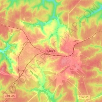
Name: Taiga topographic map, elevation, terrain.

Location: Taiga, Тайгинский городской округ, Kemerovo Oblast–Kuzbass, Siberian Federal District, 652401, Russia (56.02507 85.59133 56.10507 85.67133)

Average elevation: 817 ft

Minimum elevation: 673 ft

Maximum elevation: 899 ft

Gear up for your next adventure:

🛠️Backpacking Tool Kit - Essential toolkit for outdoor repairs
🔦LED Headlamp - Bright and durable LED headlamp for night navigation
🔊Portable Camp Speaker - Music and alerts at camp
🪓Survival Multi‑Tool - Versatile tool for camp and trail tasks
🏫Relief Map Kits - Hands-on tools for teaching landforms and elevation

As an Amazon Associate, this site earns from qualifying purchases at no extra cost to you.