Geolocate

Gedera topographic map

Click on the map to display elevation.

About this map

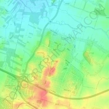
Name: Gedera topographic map, elevation, terrain.

Location: Gedera, Rehovot Subdistrict, Center District, Israel (31.79272 34.75964 31.83636 34.80100)

Average elevation: 184 ft

Minimum elevation: 102 ft

Maximum elevation: 322 ft

Other topographic maps

Click on a map to view its topography, its elevation and its terrain.

Zur Izhak

Israel > Center District

Average elevation: 276 ft

Kfar Saba

Israel > Center District

Average elevation: 177 ft

Lod

Israel > Center District

Average elevation: 200 ft

Tnuvot

Israel > Center District > Tnuvot

Average elevation: 128 ft

Hulda

Israel > Center District > Gezer Regional Council

Average elevation: 384 ft

Gear up for your next adventure:

🥾Hiking Shoes - Durable and comfortable shoes for trail hiking
🧴Hand Sanitizer - Keep hands clean while hiking
🎒Day Hiking Backpack - Lightweight backpack perfect for day trips and outdoor adventures
🥤Water Filter Bottle - All‑in‑one filter bottle for safe hydration
👖Convertible Hiking Pants - Versatile zip-off pants for changing altitudes and temperatures

As an Amazon Associate, this site earns from qualifying purchases at no extra cost to you.