
Make a donation
Gear up for your next adventure:
As an Amazon Associate, this site earns from qualifying purchases at no extra cost to you.
Manavadar topographic map
Click on the map to display elevation.
Make a donation
Gear up for your next adventure:
As an Amazon Associate, this site earns from qualifying purchases at no extra cost to you.
Manavadar
Manavadar is located at 21°30′N 70°08′E / 21.5°N 70.13°E / 21.5; 70.13. It has an average elevation of 24 metres (78 feet).
Make a donation
Gear up for your next adventure:
As an Amazon Associate, this site earns from qualifying purchases at no extra cost to you.
About this map
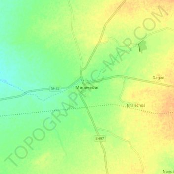
Name: Manavadar topographic map, elevation, terrain.
Location: Manavadar, Manavadar Taluka, Junagadh, Gujarat, 362630, India (21.45796 70.10065 21.53796 70.18065)
Average elevation: 98 ft
Minimum elevation: 49 ft
Maximum elevation: 138 ft
Make a donation
Gear up for your next adventure:
As an Amazon Associate, this site earns from qualifying purchases at no extra cost to you.