Geolocate

Bronx County topographic map

Click on the map to display elevation.

Bronx County

The Bronx's highest elevation at 280 feet (85 m) is in the northwest corner, west of Van Cortlandt Park and in the Chapel Farm area near the Riverdale Country School. The opposite (southeastern) side of the Bronx has four large low peninsulas or "necks" of low-lying land that jut into the waters of the East River and were once salt marsh: Hunt's Point, Clason's Point, Screvin's Neck and Throggs Neck. Further up the coastline, Rodman's Neck lies between Pelham Bay Park in the northeast and City Island. The Bronx's irregular shoreline extends for 75 square miles (194 km2).

Wikipedia (CC-BY-SA 3.0)

About this map

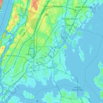
Name: Bronx County topographic map, elevation, terrain.

Location: Bronx County, New York, United States (40.78574 -73.93391 40.91763 -73.74837)

Average elevation: 69 ft

Minimum elevation: -30 ft

Maximum elevation: 456 ft

New York trails, hiking, mountain biking, running and outdoor activities

Other topographic maps

Click on a map to view its topography, its elevation and its terrain.

Central Park

United States > New York > New York County > New York

In June 1856, Fernando Wood appointed a "consulting board" of seven people, headed by author Washington Irving, to inspire public confidence in the proposed development. Wood hired military engineer Egbert Ludovicus Viele as the park's chief engineer, tasking him with a topographical survey of the site. The…

Average elevation: 85 ft

Bryant Park

United States > New York > New York County > New York

Average elevation: 66 ft

Copake

United States > New York > Copake

Average elevation: 604 ft

Central Park

United States > New York > New York County > New York

In June 1856, Fernando Wood appointed a "consulting board" of seven people, headed by author Washington Irving, to inspire public confidence in the proposed development. Wood hired military engineer Egbert Ludovicus Viele as the park's chief engineer, tasking him with a topographical survey of the site. The…

Average elevation: 85 ft

Brooklyn Bridge Park

United States > New York > Kings County > New York

Brooklyn Bridge Park spans 85 acres (34 ha) of the East River waterfront in the Brooklyn Heights and Dumbo neighborhoods of Brooklyn. The park is divided into eleven sections: Piers 1 through 6; Fulton Ferry Landing; Brooklyn Bridge Plaza; Empire Fulton Ferry; Main Street; and John Street. Each of these…

Average elevation: 30 ft

Tug Hill

United States > New York > Oswego County

The core Tug Hill region encompasses 150,000 acres (610 km2) of unbroken, generally second-growth, northern hardwood forest, and is drained by a vast network of streams. Important rivers and streams whose headwaters are located within the Tug Hill region include the Mohawk River, Deer River, Salmon River, Mad…

Average elevation: 358 ft

Inwood Hill Park

United States > New York > New York County > New York

Inwood Hill Park is a 196 acres (79 ha) public park in the Inwood neighborhood of Manhattan, New York City, operated by the New York City Department of Parks and Recreation. On a high schist ridge that rises 200 feet (61 m) above the Hudson River from Dyckman Street to the northern tip of the island, Inwood…

Average elevation: 46 ft

Aden

United States > New York > Sullivan County > Town of Neversink

Average elevation: 1,729 ft

Poe Park

United States > New York > Bronx County > New York

Average elevation: 112 ft

Mount Prosper

United States > New York > Sullivan County

Average elevation: 1,434 ft

Woodland

United States > New York > Ulster County > Town of Shandaken

Average elevation: 1,627 ft

Alpine

United States > New York > Schuyler County

Average elevation: 1,306 ft

Lake Desolation

United States > New York > Saratoga County

Average elevation: 1,542 ft

Mount Marcy

United States > New York > Essex County > Town of Keene

Mount Marcy is the highest point in the Adirondack Mountains and the U.S. state of New York, with an elevation of 5,343.1 feet (1,628.6 m). It is located in the town of Keene in Essex County. The mountain is in the heart of the High Peaks Wilderness Area in Adirondack Park. Like the surrounding Adirondack…

Average elevation: 4,229 ft

Hog Back Mountain

United States > New York > Essex County

Average elevation: 2,142 ft

Gibson Corners

United States > New York > Tioga County > Town of Owego

Average elevation: 1,348 ft

North Barton

United States > New York > Tioga County > Town of Barton

Average elevation: 1,457 ft

Peekamoose

United States > New York > Ulster County

Average elevation: 2,182 ft

Fruitland

United States > New York > Wayne County > Town of Ontario

Average elevation: 430 ft

Breakneck Ridge

United States > New York > Putnam County

Average elevation: 823 ft

Morrow Mountain

United States > New York > Madison County

Average elevation: 1,886 ft

Arthursburg

United States > New York > Dutchess County

Average elevation: 427 ft

Wellwood

United States > New York > Oswego County > Town of Mexico

Average elevation: 433 ft

Short Tract

United States > New York > Allegany County

Average elevation: 1,699 ft

Clinton Corners

United States > New York > Dutchess County

Average elevation: 374 ft

Portageville

United States > New York > Wyoming County

Average elevation: 1,266 ft

Ramapo

United States > New York > Rockland County

Average elevation: 627 ft

Brower Hill

United States > New York > Fulton County

Average elevation: 1,601 ft

Hawleyton

United States > New York > Broome County

Average elevation: 1,496 ft

Newton Falls

United States > New York > Saint Lawrence County

Average elevation: 1,496 ft

Gothicville

United States > New York > Otsego County

Average elevation: 2,018 ft

Lake Eaton

United States > New York > Essex County > Town of Jay

Average elevation: 978 ft

Dashville

United States > New York > Ulster County > Town of Esopus

Average elevation: 289 ft

Livingston Manor

United States > New York > Sullivan County

Average elevation: 1,709 ft

Astoria Park

United States > New York > Queens County > New York

Average elevation: 26 ft

Oak Ridge

United States > New York > Montgomery County

Average elevation: 1,257 ft

Lagrange

United States > New York > Wyoming County > Town of Perry

Average elevation: 1,312 ft

Nelson Corners

United States > New York > Putnam County

Average elevation: 617 ft

Hoboken

United States > New York > Otsego County

Average elevation: 1,230 ft

Atwood

United States > New York > Ulster County

Average elevation: 495 ft

Burnwood

United States > New York > Delaware County > Town of Hancock

Average elevation: 1,716 ft

Riparius

United States > New York > Warren County

Average elevation: 1,096 ft

North Osceola

United States > New York > Lewis County

Average elevation: 1,614 ft

Blue Ridge

United States > New York > Essex County

Average elevation: 1,437 ft

Varysburg

United States > New York > Wyoming County > Town of Sheldon

Average elevation: 1,401 ft

Prussian Settlement

United States > New York > Lewis County

Average elevation: 1,562 ft

Fort Johnson

United States > New York > Montgomery County

Average elevation: 453 ft

Big Moose

United States > New York > Herkimer County

Average elevation: 2,034 ft

Gear up for your next adventure:

🔊Portable Camp Speaker - Music and alerts at camp
📚USA Hiking Guide Books - Top trail guides and map books
🌡️Portable Weather Meter - Track weather conditions on the trail
🦶Hiking Gaiters - Keep debris and water out of your boots
🌐World Map Poster - Decorative world maps with topographic info

As an Amazon Associate, this site earns from qualifying purchases at no extra cost to you.