
Make a donation
Gear up for your next adventure:
As an Amazon Associate, this site earns from qualifying purchases at no extra cost to you.
Good Hope topographic map
Click on the map to display elevation.
Make a donation
Gear up for your next adventure:
As an Amazon Associate, this site earns from qualifying purchases at no extra cost to you.
About this map
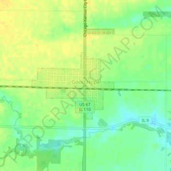
Name: Good Hope topographic map, elevation, terrain.
Location: Good Hope, McDonough County, Illinois, United States (40.55193 -90.68472 40.56249 -90.66760)
Average elevation: 709 ft
Minimum elevation: 663 ft
Maximum elevation: 741 ft
McDonough County trails, hiking, mountain biking, running and outdoor activities
Make a donation
Gear up for your next adventure:
As an Amazon Associate, this site earns from qualifying purchases at no extra cost to you.
Other topographic maps
Click on a map to view its topography, its elevation and its terrain.
Lamone Village
United States > Illinois > McDonough County > Macomb > Lamone Village
Average elevation: 673 ft