
Make a donation
Gear up for your next adventure:
As an Amazon Associate, this site earns from qualifying purchases at no extra cost to you.
Altenkessel topographic map
Click on the map to display elevation.
Make a donation
Gear up for your next adventure:
As an Amazon Associate, this site earns from qualifying purchases at no extra cost to you.
Altenkessel
Beginnend vom nördlichen Saartal erstreckt sich Altenkessel bis auf die Höhen des Pfaffenkopfes. Der Ort liegt an der Barockstraße SaarPfalz.
Make a donation
Gear up for your next adventure:
As an Amazon Associate, this site earns from qualifying purchases at no extra cost to you.
About this map
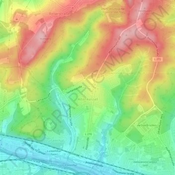
Name: Altenkessel topographic map, elevation, terrain.
Average elevation: 850 ft
Minimum elevation: 591 ft
Maximum elevation: 1,152 ft
Make a donation
Gear up for your next adventure:
As an Amazon Associate, this site earns from qualifying purchases at no extra cost to you.
Other topographic maps
Click on a map to view its topography, its elevation and its terrain.
Staffelberg
Deutschland > Saarland > Regionalverband Saarbrücken > Saarbrücken
Average elevation: 1,086 ft
Großer Homburg
Deutschland > Saarland > Regionalverband Saarbrücken > Saarbrücken
Average elevation: 850 ft
Neu-Aschbach
Deutschland > Saarland > Regionalverband Saarbrücken > Saarbrücken
Average elevation: 764 ft
Make a donation
Gear up for your next adventure:
As an Amazon Associate, this site earns from qualifying purchases at no extra cost to you.
Pfaffenkopf
Deutschland > Saarland > Regionalverband Saarbrücken > Saarbrücken
Average elevation: 965 ft