Geolocate

Three Rivers topographic map

Click on the map to display elevation.

About this map

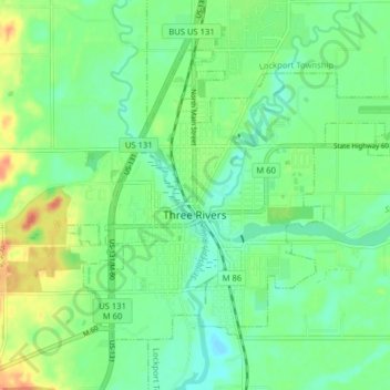
Name: Three Rivers topographic map, elevation, terrain.

Location: Three Rivers, Saint Joseph County, Michigan, United States (41.92541 -85.66057 41.96927 -85.58125)

Average elevation: 823 ft

Minimum elevation: 771 ft

Maximum elevation: 912 ft

Saint Joseph County trails, hiking, mountain biking, running and outdoor activities

Other topographic maps

Click on a map to view its topography, its elevation and its terrain.

Sandy Beach

United States > Michigan > Saint Joseph County

Average elevation: 843 ft

Gear up for your next adventure:

🕶️Glacier Sunglasses - Side shields to protect eyes from high-altitude snow glare
🥾Women's Hiking Boots - Top-rated trail boots with ankle support and superior grip
🧦Merino Wool Socks - Moisture-wicking, blister-preventing socks for long treks
🌡️Portable Weather Meter - Track weather conditions on the trail
🎒Waterproof Dry Bags - Keep your electronics and maps dry inside your pack

As an Amazon Associate, this site earns from qualifying purchases at no extra cost to you.