
Make a donation
Gear up for your next adventure:
As an Amazon Associate, this site earns from qualifying purchases at no extra cost to you.
Lohr am Main topographic map
Click on the map to display elevation.
Make a donation
Gear up for your next adventure:
As an Amazon Associate, this site earns from qualifying purchases at no extra cost to you.
Lohr am Main
The Main river valley is steep with an elevation change from 160 m above sea level at Gemünden dropping to 100 m above sea level at Hanau. The river Main in its natural state is a fast-moving stream unsuitable for shipping. In the 19th century the river was tamed and a system of dams and locks is now part of the Rhine-Main-Danube Canal connecting the North Sea with the Black Sea.
Make a donation
Gear up for your next adventure:
As an Amazon Associate, this site earns from qualifying purchases at no extra cost to you.
About this map
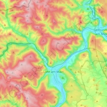
Name: Lohr am Main topographic map, elevation, terrain.
Location: Lohr am Main, Landkreis Main-Spessart, Bavaria, 97816, Germany (49.94032 9.47883 50.10555 9.67930)
Average elevation: 1,102 ft
Minimum elevation: 486 ft
Maximum elevation: 1,877 ft
Make a donation
Gear up for your next adventure:
As an Amazon Associate, this site earns from qualifying purchases at no extra cost to you.
Other topographic maps
Click on a map to view its topography, its elevation and its terrain.