Geolocate

Norwood topographic map

Click on the map to display elevation.

About this map

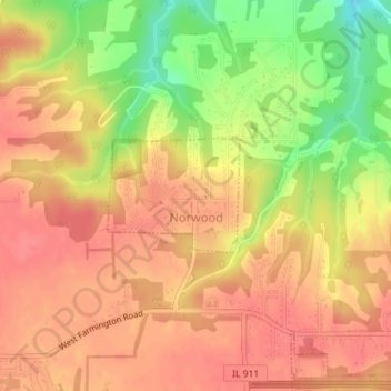
Name: Norwood topographic map, elevation, terrain.

Location: Norwood, Peoria County, Illinois, United States (40.70314 -89.70682 40.71103 -89.69473)

Average elevation: 656 ft

Minimum elevation: 509 ft

Maximum elevation: 728 ft

Peoria County trails, hiking, mountain biking, running and outdoor activities

Other topographic maps

Click on a map to view its topography, its elevation and its terrain.

Detweiller Park

United States > Illinois > Peoria County > Peoria

Average elevation: 610 ft

Mossville

United States > Illinois > Peoria County

Average elevation: 512 ft

Maxwell

United States > Illinois > Peoria County

Average elevation: 679 ft

Gear up for your next adventure:

Camping Coffee Makers - Enjoy premium coffee at the summit or campsite
🦶Carbon Trekking Poles - Reduce knee impact on steep descents with ultra-light poles
🗃️Trail First Aid Kit - Essential kit for outdoor injuries and emergencies
🥇GPS Hiking Watch - Multi‑sport GPS watch with navigation and trail tracking
🦟Ultrasonic Repellers - Create a bug-free zone at your camp or rest stop

As an Amazon Associate, this site earns from qualifying purchases at no extra cost to you.