
Make a donation
Gear up for your next adventure:
As an Amazon Associate, this site earns from qualifying purchases at no extra cost to you.
Chalford topographic map
Click on the map to display elevation.
Make a donation
Gear up for your next adventure:
As an Amazon Associate, this site earns from qualifying purchases at no extra cost to you.
About this map
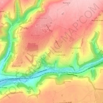
Name: Chalford topographic map, elevation, terrain.
Location: Chalford, Stroud, Gloucestershire, England, United Kingdom (51.71868 -2.17989 51.73559 -2.12816)
Average elevation: 558 ft
Minimum elevation: 203 ft
Maximum elevation: 774 ft
Make a donation
Gear up for your next adventure:
As an Amazon Associate, this site earns from qualifying purchases at no extra cost to you.
Other topographic maps
Click on a map to view its topography, its elevation and its terrain.
Chalford Hill
United Kingdom > England > Gloucestershire > Stroud > Chalford
Average elevation: 574 ft
River Frome
United Kingdom > England > Gloucestershire > Stroud > Chalford > Chalford Hill
Average elevation: 535 ft