
Make a donation
Gear up for your next adventure:
As an Amazon Associate, this site earns from qualifying purchases at no extra cost to you.
Opheusden topographic map
Click on the map to display elevation.
Make a donation
Gear up for your next adventure:
As an Amazon Associate, this site earns from qualifying purchases at no extra cost to you.
Opheusden
Opheusden ligt voorts aan de zuidoever van de Nederrijn en in de streek Neder-Betuwe. Het dorp en zijn omgeving kenmerken zich door een vlak rivierenlandschap op ongeveer zes meter hoogte met veel tuinbouw. Opheusden staat bekend om zijn grootschalige laanboomkwekerijen en laat zich er op voorstaan een van de grootsten op dat gebied in Europa te zijn.
Make a donation
Gear up for your next adventure:
As an Amazon Associate, this site earns from qualifying purchases at no extra cost to you.
About this map
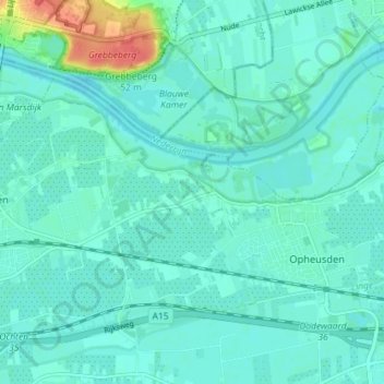
Name: Opheusden topographic map, elevation, terrain.
Location: Opheusden, Neder-Betuwe, Gelderland, Nederland (51.92044 5.59611 51.95401 5.66776)
Average elevation: 33 ft
Minimum elevation: 3 ft
Maximum elevation: 164 ft
Make a donation
Gear up for your next adventure:
As an Amazon Associate, this site earns from qualifying purchases at no extra cost to you.