
Wartau topographic map
Interactive map
Click on the map to display elevation.
About this map
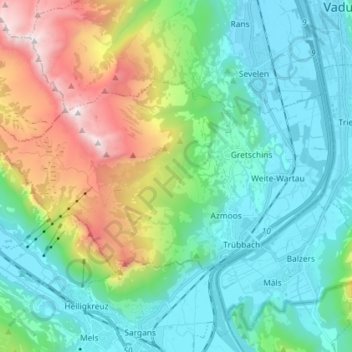
Name: Wartau topographic map, elevation, terrain.
Location: Wartau, Wahlkreis Werdenberg, Saint-Gall, Suisse (47.06479 9.37538 47.11934 9.51958)
Average elevation: 3,117 ft
Minimum elevation: 1,470 ft
Maximum elevation: 7,720 ft
Other topographic maps
Click on a map to view its topography, its elevation and its terrain.
Gams
Suisse > Saint-Gall > Wahlkreis Werdenberg
Gams, Wahlkreis Werdenberg, Saint-Gall, 9473, Suisse
Average elevation: 2,589 ft
Grabs
Suisse > Saint-Gall > Wahlkreis Werdenberg > Grabs
Grabs, Wahlkreis Werdenberg, Saint-Gall, 9472, Suisse
Average elevation: 3,005 ft
Buchs (SG)
Suisse > Saint-Gall > Wahlkreis Werdenberg
Buchs (SG), Wahlkreis Werdenberg, Saint-Gall, Suisse
Average elevation: 1,890 ft
Oberschan
Suisse > Saint-Gall > Wahlkreis Werdenberg > Wartau
Oberschan, Wartau, Wahlkreis Werdenberg, Saint-Gall, 9479, Suisse
Average elevation: 2,470 ft