
Palma Sola topographic map
Interactive map
Click on the map to display elevation.
About this map
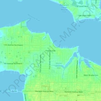
Name: Palma Sola topographic map, elevation, terrain.
Location: Palma Sola, Manatee County, Florida, 34209, United States (27.49226 -82.65204 27.53226 -82.61204)
Average elevation: 13 ft
Minimum elevation: -7 ft
Maximum elevation: 39 ft
Manatee County trails, hiking, mountain biking, running and outdoor activities
Other topographic maps
Click on a map to view its topography, its elevation and its terrain.
Summerfield Community Park
United States > Florida > Manatee County > Bradenton
Average elevation: 33 ft
Anna Maria Bayfront Park
United States > Florida > Manatee County > Anna Maria island
Average elevation: 3 ft