
Lake Peekskill topographic map
Click on the map to display elevation.
About this map
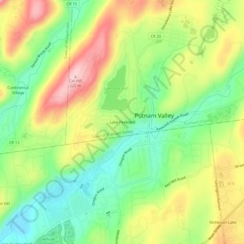
Name: Lake Peekskill topographic map, elevation, terrain.
Average elevation: 338 ft
Minimum elevation: 30 ft
Maximum elevation: 735 ft
Putnam County trails, hiking, mountain biking, running and outdoor activities
Other topographic maps
Click on a map to view its topography, its elevation and its terrain.
Clarence Fahnestock Memorial State Park
United States > New York > Putnam County > Town of Putnam Valley
Average elevation: 679 ft
Kent Cliffs Unit
United States > New York > Putnam County > Town of Putnam Valley > Richardsville
Average elevation: 886 ft
Stillwater Pond
United States > New York > Putnam County > Town of Putnam Valley
Average elevation: 945 ft