Geolocate

Clark topographic map

Click on the map to display elevation.

About this map

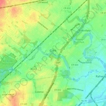
Name: Clark topographic map, elevation, terrain.

Location: Clark, Union County, New Jersey, United States (40.60354 -74.35912 40.63998 -74.27692)

Average elevation: 75 ft

Minimum elevation: 7 ft

Maximum elevation: 177 ft

Union County trails, hiking, mountain biking, running and outdoor activities

Other topographic maps

Click on a map to view its topography, its elevation and its terrain.

Woodland Park

United States > New Jersey > Union County > Summit

Average elevation: 361 ft

Milton Lake

United States > New Jersey > Union County > Rahway

Average elevation: 59 ft

Sunnyside

United States > New Jersey > Union County > Linden

Average elevation: 56 ft

Tremley

United States > New Jersey > Union County > Linden

Average elevation: 13 ft

Woodland Park

United States > New Jersey > Union County > Summit

Average elevation: 361 ft

Tremont Park

United States > New Jersey > Union County > Summit

Average elevation: 335 ft

Gear up for your next adventure:

👟Trail Running Shoes - Lightweight shoes for trail runners
🧭GPS Watch Accessories - Bands and chargers for GPS watches
🧦Hiking Socks - Comfortable socks to prevent blisters on long hikes
🔌USB Car Charger - Car charger for on‑the‑go power needs
🧦Merino Wool Socks - Moisture-wicking, blister-preventing socks for long treks

As an Amazon Associate, this site earns from qualifying purchases at no extra cost to you.