Geolocate

Parasapas topographic map

Interactive map

Click on the map to display elevation.

About this map

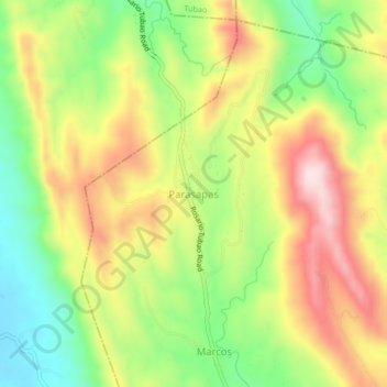
Name: Parasapas topographic map, elevation, terrain.

Location: Parasapas, Santo Tomas, La Union, Ilocos Region, 2508, Philippines (16.26146 120.42346 16.30146 120.46346)

Average elevation: 663 ft

Minimum elevation: 82 ft

Maximum elevation: 1,299 ft

Other topographic maps

Click on a map to view its topography, its elevation and its terrain.

Sungyot Island

Philippines > La Union > Santo Tomas

Sungyot Island, Santo Tomas, La Union, Ilocos Region, Philippines

Average elevation: 0 ft

Cupang

Philippines > La Union > Santo Tomas

Cupang, Santo Tomas, La Union, Ilocos Region, Philippines

Average elevation: 75 ft

Tubod

Philippines > La Union > Santo Tomas

Tubod, Santo Tomas, La Union, Ilocos Region, Philippines

Average elevation: 79 ft

Agoo-Damortis Protected Landscape and Seascape

Philippines > La Union > Santo Tomas

Agoo-Damortis Protected Landscape and Seascape, Santo Tomas, La Union, Ilocos Region, Philippines

Average elevation: 30 ft

Damortis

Philippines > La Union > Santo Tomas

Damortis, Santo Tomas, La Union, Philippines

Average elevation: 82 ft

Santo Tomas

Philippines > La Union > Santo Tomas

Santo Tomas, La Union, Ilocos Region, 2505, Philippines

Average elevation: 131 ft