
Kazan topographic map
Interactive map
Click on the map to display elevation.
About this map
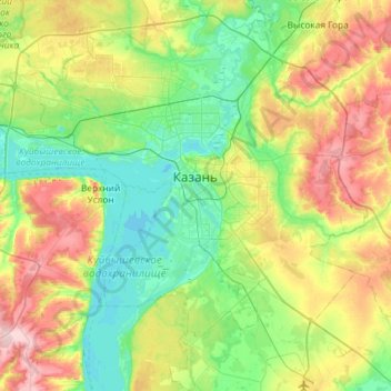
Name: Kazan topographic map, elevation, terrain.
Average elevation: 341 ft
Minimum elevation: 148 ft
Maximum elevation: 755 ft
Other topographic maps
Click on a map to view its topography, its elevation and its terrain.
Танковое кольцо
Russia > Tatarstan > городской округ Казань > Kazan
Танковое кольцо, Kalininski, Приволжский район, Kazan, городской округ Казань, Tatarstan, Volga Federal District, 420059, Russia
Average elevation: 233 ft