
Madison topographic map
Click on the map to display elevation.
Madison
The city is sometimes described as The City of Four Lakes, comprising the four successive lakes of the Yahara River: Lake Mendota ("Fourth Lake"), Lake Monona ("Third Lake"), Lake Waubesa ("Second Lake") and Lake Kegonsa ("First Lake"), although Waubesa and Kegonsa are not actually in Madison, but just south of it. A fifth smaller lake, Lake Wingra, is within the city as well; it is connected to the Yahara River chain by Wingra Creek. The Yahara flows into the Rock River, which flows into the Mississippi River. Downtown Madison is located on an isthmus between Lakes Mendota and Monona. The city's trademark of "Lake, City, Lake" reflects this geography. The city's lowest elevation is the intersection of Regas Road and Corporate Drive on the east side, at 836.9 ft (255.1 m). The highest elevation is located along Pleasant View Road on the far west side of the city, atop a portion of a terminal moraine of the Green Bay Lobe of the Wisconsin glaciation, at 1,190 ft (360 m).
About this map
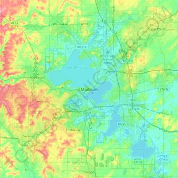
Name: Madison topographic map, elevation, terrain.
Location: Madison, Dane County, Wisconsin, 53703, United States (42.91476 -89.54376 43.23476 -89.22376)
Average elevation: 948 ft
Minimum elevation: 837 ft
Maximum elevation: 1,237 ft
Dane County trails, hiking, mountain biking, running and outdoor activities
Other topographic maps
Click on a map to view its topography, its elevation and its terrain.
Glacial Valley Park
United States > Wisconsin > Dane County > Village of Cross Plains
Average elevation: 942 ft
Indian Lake County Park
United States > Wisconsin > Dane County > Town of Berry
Average elevation: 1,037 ft
Brooklyn State Wildlife Area
United States > Wisconsin > Dane County > Town of Union > Town of Rutland
Average elevation: 951 ft
Governor Nelson State Park
United States > Wisconsin > Dane County > Waunakee
Average elevation: 873 ft