
Mount Vernon topographic map
Click on the map to display elevation.
About this map
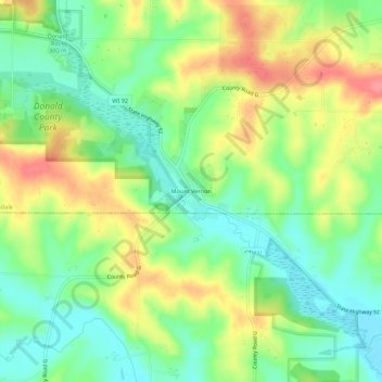
Name: Mount Vernon topographic map, elevation, terrain.
Average elevation: 994 ft
Minimum elevation: 883 ft
Maximum elevation: 1,148 ft
Dane County trails, hiking, mountain biking, running and outdoor activities
Other topographic maps
Click on a map to view its topography, its elevation and its terrain.
Glacial Valley Park
United States > Wisconsin > Dane County > Village of Cross Plains
Average elevation: 942 ft
Indian Lake County Park
United States > Wisconsin > Dane County > Town of Berry
Average elevation: 1,037 ft
Brooklyn State Wildlife Area
United States > Wisconsin > Dane County > Town of Union > Town of Rutland
Average elevation: 951 ft
Governor Nelson State Park
United States > Wisconsin > Dane County > Waunakee
Average elevation: 873 ft