
Make a donation
Gear up for your next adventure:
As an Amazon Associate, this site earns from qualifying purchases at no extra cost to you.
Sint-Joris-Weert topographic map
Click on the map to display elevation.
Make a donation
Gear up for your next adventure:
As an Amazon Associate, this site earns from qualifying purchases at no extra cost to you.
Sint-Joris-Weert
Sint-Joris-Weert ligt op het Brabants Plateau op een hoogte van 28-71 meter, aan de Dijle. In het oosten strekt het Meerdaalwoud zich uit, in het noorden vindt men het Kouterbos en in het westen ligt, in de vallei van de Dijle, de Doode Bemde.
Make a donation
Gear up for your next adventure:
As an Amazon Associate, this site earns from qualifying purchases at no extra cost to you.
About this map
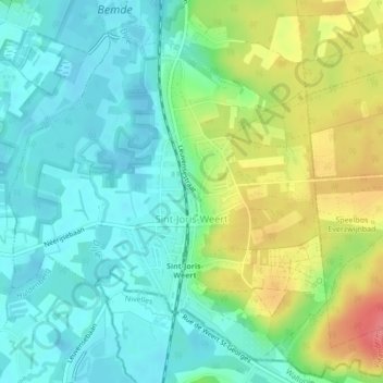
Name: Sint-Joris-Weert topographic map, elevation, terrain.
Average elevation: 151 ft
Minimum elevation: 72 ft
Maximum elevation: 312 ft
Make a donation
Gear up for your next adventure:
As an Amazon Associate, this site earns from qualifying purchases at no extra cost to you.