
Bhilangna River topographic map
Interactive map
Click on the map to display elevation.
About this map
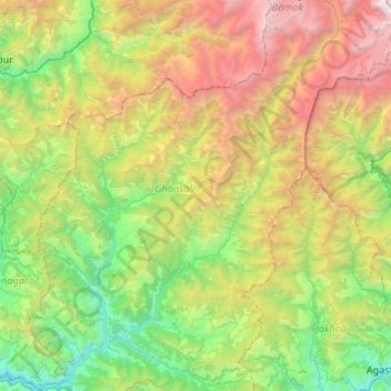
Name: Bhilangna River topographic map, elevation, terrain.
Average elevation: 8,346 ft
Minimum elevation: 2,274 ft
Maximum elevation: 20,584 ft
Other topographic maps
Click on a map to view its topography, its elevation and its terrain.
Jamroli
India > Uttarakhand > Ghansali
Jamroli, Ghansali, Tehri Garhwal, Uttarakhand, India
Average elevation: 7,021 ft
shrikol
India > Uttarakhand > Ghansali > chamyala
shrikol, chamyala, Ghansali, Tehri Garhwal, Uttarakhand, 249181, India
Average elevation: 4,131 ft
sakari
India > Uttarakhand > Ghansali > Pauli
sakari, Pauli, Ghansali, Tehri Garhwal, Uttarakhand, India
Average elevation: 4,820 ft
beleshwar
India > Uttarakhand > Ghansali > beleshwar
beleshwar, Ghansali, Tehri Garhwal, Uttarakhand, 249181, India
Average elevation: 4,019 ft