Geolocate

Ballari topographic map

Click on the map to display elevation.

About this map

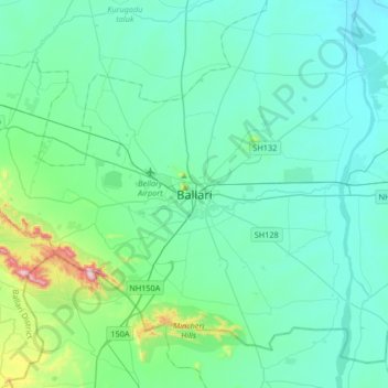
Name: Ballari topographic map, elevation, terrain.

Location: Ballari, Bellary taluk, Ballari, Karnataka, 583101, India (14.98340 76.75939 15.30340 77.07939)

Average elevation: 1,542 ft

Minimum elevation: 1,280 ft

Maximum elevation: 3,166 ft

Gear up for your next adventure:

🛡️Insect Repellent - Protection against bugs during outdoor activities
🎒Outdoor Daypacks - Lightweight backpacks designed for carrying maps and essential gear
🪑Ultralight Camp Chairs - Portable seating for resting after a long day of mapping
📷Action Camera - Capture your outdoor adventures in HD
💧Water Filtration Bottles - Safely drink from streams and lakes while exploring

As an Amazon Associate, this site earns from qualifying purchases at no extra cost to you.