
Make a donation
Gear up for your next adventure:
As an Amazon Associate, this site earns from qualifying purchases at no extra cost to you.
Quesnel topographic map
Click on the map to display elevation.
Make a donation
Gear up for your next adventure:
As an Amazon Associate, this site earns from qualifying purchases at no extra cost to you.
About this map
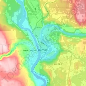
Name: Quesnel topographic map, elevation, terrain.
Average elevation: 1,926 ft
Minimum elevation: 1,506 ft
Maximum elevation: 2,602 ft
Make a donation
Gear up for your next adventure:
As an Amazon Associate, this site earns from qualifying purchases at no extra cost to you.
Other topographic maps
Click on a map to view its topography, its elevation and its terrain.
Big Lake
Canada > British Columbia > Cariboo Regional District > Area J (West Chilcotin)
Average elevation: 4,364 ft
Big Lake Ranch
Canada > British Columbia > Cariboo Regional District > Area F (Horsefly/Likely/150 Mile House)
Average elevation: 2,979 ft
Diamond Island
Canada > British Columbia > Cariboo Regional District > Area A (Red Bluff/Quesnel South) > Alexandria
Average elevation: 1,545 ft
Trail Ridge
Canada > British Columbia > Cariboo Regional District > Area K (East Chilcotin)
Average elevation: 7,762 ft
Make a donation
Gear up for your next adventure:
As an Amazon Associate, this site earns from qualifying purchases at no extra cost to you.
Likely
Canada > British Columbia > Cariboo Regional District > Area F (Horsefly/Likely/150 Mile House) > Likely
Average elevation: 2,904 ft
Fish Trap (Dean River) Recreation Site
Canada > British Columbia > Cariboo Regional District > Area J (West Chilcotin)
Average elevation: 3,701 ft
150 Mile House
Canada > British Columbia > Cariboo Regional District > Area F (Horsefly/Likely/150 Mile House) > 150 Mile House
Average elevation: 2,589 ft
Make a donation
Gear up for your next adventure:
As an Amazon Associate, this site earns from qualifying purchases at no extra cost to you.
Mahood Lake
Canada > British Columbia > Cariboo Regional District > Area H (Canim Lake/Forest Grove)
Average elevation: 3,789 ft