
Irazú Volcano topographic map
Click on the map to display elevation.
Irazú Volcano
The Irazú volcano is a complex volcanic shield. It is the highest active volcano in Costa Rica, and has an area of 500 km2 (190 sq mi). It has an irregular subconic shape, and temperatures at its summit vary between 3 and 17 °C (37 and 63 °F), with a record low of −3 °C(26.6 °F) and a record high of 23.2 °C(73.4 °F). Irazu volcano is a stratovolcano with a summit elevation of 3,432 metres (11,260 ft). Its five craters are easily differentiated. The most important ones, because of their activity, are The Main Crater and the Diego de la Haya crater. The Main Crater is almost circular, has very inclined walls and it measures 1,050 metres (3,440 ft) in diameter and 300 metres (980 ft) deep. The Diego de la Haya crater is 600 metres (2,000 ft) in diameter and 100 metres (330 ft) deep. Other craters are Playa Hermosa, La Laguna, and El Piroclastico.
About this map
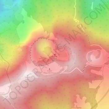
Name: Irazú Volcano topographic map, elevation, terrain.
Average elevation: 10,217 ft
Minimum elevation: 8,153 ft
Maximum elevation: 11,224 ft