
Make a donation
Gear up for your next adventure:
As an Amazon Associate, this site earns from qualifying purchases at no extra cost to you.
Surwold topographic map
Click on the map to display elevation.
Make a donation
Gear up for your next adventure:
As an Amazon Associate, this site earns from qualifying purchases at no extra cost to you.
Surwold
Der südlich gelegene Ortsteil Börgerwald mit rd. 1.800 Einwohnern liegt am nördlichen Rande des hügeligen und waldreichen Hümmlings, 5–42 Meter über dem Meeresspiegel. Die Nutzung der Landschaft ist durch die Landwirtschaft geprägt. Bemerkenswert ist die „Serpentine“ der L51 im Bereich der Grundschule, hier wird ein Höhenunterschied von rund 15 m überwunden, die Steigung der Straße beträgt rund 8 %. Bekanntester Höhenzug der Gegend ist der Wattberg mit einer Höhe von 34 Metern üNN.
Make a donation
Gear up for your next adventure:
As an Amazon Associate, this site earns from qualifying purchases at no extra cost to you.
About this map
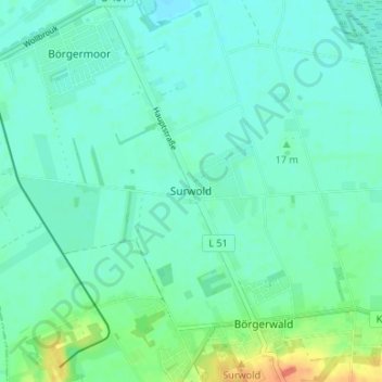
Name: Surwold topographic map, elevation, terrain.
Average elevation: 36 ft
Minimum elevation: 7 ft
Maximum elevation: 138 ft
Make a donation
Gear up for your next adventure:
As an Amazon Associate, this site earns from qualifying purchases at no extra cost to you.