
Make a donation
Gear up for your next adventure:
As an Amazon Associate, this site earns from qualifying purchases at no extra cost to you.
Cerro El Toro topographic map
Click on the map to display elevation.
Make a donation
Gear up for your next adventure:
As an Amazon Associate, this site earns from qualifying purchases at no extra cost to you.
About this map
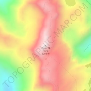
Name: Cerro El Toro topographic map, elevation, terrain.
Average elevation: 6,214 ft
Minimum elevation: 4,426 ft
Maximum elevation: 7,530 ft
Make a donation
Gear up for your next adventure:
As an Amazon Associate, this site earns from qualifying purchases at no extra cost to you.
Other topographic maps
Click on a map to view its topography, its elevation and its terrain.
Parque Nacional Laguna del Laja
Chile > Región del Biobío > Provincia de Bío-Bío > Antuco
Average elevation: 5,650 ft
Estero de Trapatrapa
Chile > Región del Biobío > Provincia de Bío-Bío > Antuco
Average elevation: 5,568 ft
Río de los Pinos
Chile > Región del Biobío > Provincia de Bío-Bío > Antuco
Average elevation: 5,427 ft