
Make a donation
Gear up for your next adventure:
As an Amazon Associate, this site earns from qualifying purchases at no extra cost to you.
Reningelst topographic map
Click on the map to display elevation.
Make a donation
Gear up for your next adventure:
As an Amazon Associate, this site earns from qualifying purchases at no extra cost to you.
Reningelst
Reningelst ligt in Zandlemig Vlaanderen en de hoogte varieert van 20 meter tot 80 meter. Reningelst ligt aan de voet van het West-Vlaams Heuvelland. Waterlopen zijn de Pandoenbeek die, samen met de Franse Beek, verder naar het noordoosten de Grote Beek vormt. Oostelijk daarvan stroomt de Scherpenbergbeek.
Make a donation
Gear up for your next adventure:
As an Amazon Associate, this site earns from qualifying purchases at no extra cost to you.
About this map
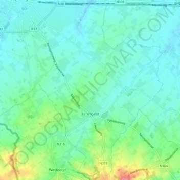
Name: Reningelst topographic map, elevation, terrain.
Average elevation: 118 ft
Minimum elevation: 52 ft
Maximum elevation: 351 ft
Make a donation
Gear up for your next adventure:
As an Amazon Associate, this site earns from qualifying purchases at no extra cost to you.
Other topographic maps
Click on a map to view its topography, its elevation and its terrain.
Roesbrugge
België > West-Vlaanderen > Ieper > Poperinge
Roesbrugge ligt aan de IJzer op een hoogte van ongeveer 7 meter. Naar het zuidoosten toe strekt Zandlemig Vlaanderen zich uit, met lichte glooiing. De IJzervallei tussen Roesbrugge-Haringe en Elzendamme en de vallei van de Poperingevaart is een cultuurhistorische ankerplaats.
Average elevation: 23 ft