Geolocate

Gordon topographic map

Click on the map to display elevation.

About this map

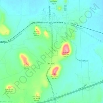
Name: Gordon topographic map, elevation, terrain.

Location: Gordon, Palo Pinto County, Texas, 76453, United States (32.51288 -98.38088 32.55879 -98.35693)

Average elevation: 1,007 ft

Minimum elevation: 925 ft

Maximum elevation: 1,276 ft

Palo Pinto County trails, hiking, mountain biking, running and outdoor activities

Other topographic maps

Click on a map to view its topography, its elevation and its terrain.

New Salem

United States > Texas > Palo Pinto County

Average elevation: 863 ft

Brazos

United States > Texas > Palo Pinto County

Average elevation: 837 ft

Gordon

United States > Texas > Palo Pinto County > Gordon > Gordon

Average elevation: 988 ft

Gear up for your next adventure:

🪶Fire Starter Kit - Reliable fire starter for survival and camping
🪶Trail Camera - Capture wildlife on your hikes
🛡️Insect Repellent - Protection against bugs during outdoor activities
📌Outdoor GPS Map App - Apps and devices for digital topographic navigation
🪶Survival Guide Book - Expert advice for emergency preparedness

As an Amazon Associate, this site earns from qualifying purchases at no extra cost to you.