
Thank you for supporting this site ❤️
Make a donation
Make a donation
Gear up for your next adventure:
As an Amazon Associate, this site earns from qualifying purchases at no extra cost to you.
Gordon topographic map
Click on the map to display elevation.
Thank you for supporting this site ❤️
Make a donation
Make a donation
Gear up for your next adventure:
As an Amazon Associate, this site earns from qualifying purchases at no extra cost to you.
About this map
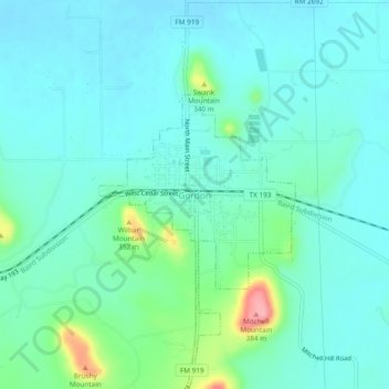
Name: Gordon topographic map, elevation, terrain.
Location: Gordon, Palo Pinto County, Texas, 76453, United States (32.52846 -98.38922 32.56846 -98.34922)
Average elevation: 988 ft
Minimum elevation: 915 ft
Maximum elevation: 1,276 ft
Palo Pinto County trails, hiking, mountain biking, running and outdoor activities
Thank you for supporting this site ❤️
Make a donation
Make a donation
Gear up for your next adventure:
As an Amazon Associate, this site earns from qualifying purchases at no extra cost to you.