
Thank you for supporting this site ❤️
Make a donation
Make a donation
Gear up for your next adventure:
As an Amazon Associate, this site earns from qualifying purchases at no extra cost to you.
Paccekke topographic map
Click on the map to display elevation.
Thank you for supporting this site ❤️
Make a donation
Make a donation
Gear up for your next adventure:
As an Amazon Associate, this site earns from qualifying purchases at no extra cost to you.
About this map
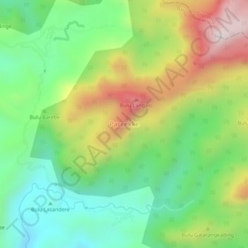
Name: Paccekke topographic map, elevation, terrain.
Location: Paccekke, Barru, South Sulawesi, Sulawesi, Indonesia (-4.29246 119.69368 -4.25246 119.73368)
Average elevation: 1,444 ft
Minimum elevation: 384 ft
Maximum elevation: 3,120 ft
Thank you for supporting this site ❤️
Make a donation
Make a donation
Gear up for your next adventure:
As an Amazon Associate, this site earns from qualifying purchases at no extra cost to you.