
Make a donation
Gear up for your next adventure:
As an Amazon Associate, this site earns from qualifying purchases at no extra cost to you.
Placilla topographic map
Click on the map to display elevation.
Make a donation
Gear up for your next adventure:
As an Amazon Associate, this site earns from qualifying purchases at no extra cost to you.
About this map
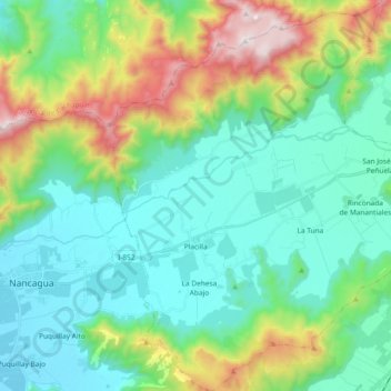
Name: Placilla topographic map, elevation, terrain.
Average elevation: 1,490 ft
Minimum elevation: 663 ft
Maximum elevation: 3,937 ft
Make a donation
Gear up for your next adventure:
As an Amazon Associate, this site earns from qualifying purchases at no extra cost to you.
Other topographic maps
Click on a map to view its topography, its elevation and its terrain.
Las Peñas
Chile > Región del Libertador General Bernardo O'Higgins > Provincia de Colchagua > San Fernando
Average elevation: 2,536 ft
Valle del Encanto
Chile > Región del Libertador General Bernardo O'Higgins > Provincia de Colchagua > San Fernando
Average elevation: 2,605 ft
Las Majadas
Chile > Región del Libertador General Bernardo O'Higgins > Provincia de Colchagua
Average elevation: 459 ft
Colchagua
Chile > Región del Libertador General Bernardo O'Higgins > Provincia de Colchagua > Palmilla
Average elevation: 525 ft
Make a donation
Gear up for your next adventure:
As an Amazon Associate, this site earns from qualifying purchases at no extra cost to you.
La Marinana
Chile > Región del Libertador General Bernardo O'Higgins > Provincia de Colchagua > San Fernando > Roma
Average elevation: 1,260 ft
Roma
Chile > Región del Libertador General Bernardo O'Higgins > Provincia de Colchagua > San Fernando
Average elevation: 1,335 ft
Santa Isabel
Chile > Región del Libertador General Bernardo O'Higgins > Provincia de Colchagua > San Fernando > Quilapán - Polonia
Average elevation: 1,047 ft
Agua Buena
Chile > Región del Libertador General Bernardo O'Higgins > Provincia de Colchagua > San Fernando
Average elevation: 1,791 ft
Make a donation
Gear up for your next adventure:
As an Amazon Associate, this site earns from qualifying purchases at no extra cost to you.
Puente Negro
Chile > Región del Libertador General Bernardo O'Higgins > Provincia de Colchagua > San Fernando
Average elevation: 1,755 ft
Viña Apalta
Chile > Región del Libertador General Bernardo O'Higgins > Provincia de Colchagua > Santa Cruz > Millahue de Apalta
Average elevation: 689 ft
Pupilla
Chile > Región del Libertador General Bernardo O'Higgins > Provincia de Colchagua > San José del Carmen > Pupilla
Average elevation: 476 ft
Candelaria
Chile > Región del Libertador General Bernardo O'Higgins > Provincia de Colchagua > Chépica
Average elevation: 928 ft
Make a donation
Gear up for your next adventure:
As an Amazon Associate, this site earns from qualifying purchases at no extra cost to you.
Termas del Flaco
Chile > Región del Libertador General Bernardo O'Higgins > Provincia de Colchagua > San Fernando
Average elevation: 6,670 ft
San José del Carmen
Chile > Región del Libertador General Bernardo O'Higgins > Provincia de Colchagua
Average elevation: 472 ft
Pan de Azúcar
Chile > Región del Libertador General Bernardo O'Higgins > Provincia de Colchagua > Santa Cruz
Average elevation: 735 ft
Las Garzas
Chile > Región del Libertador General Bernardo O'Higgins > Provincia de Colchagua > Palmilla
Average elevation: 469 ft
Make a donation
Gear up for your next adventure:
As an Amazon Associate, this site earns from qualifying purchases at no extra cost to you.