
Make a donation
Gear up for your next adventure:
As an Amazon Associate, this site earns from qualifying purchases at no extra cost to you.
Monte Maggiorasca topographic map
Click on the map to display elevation.
Make a donation
Gear up for your next adventure:
As an Amazon Associate, this site earns from qualifying purchases at no extra cost to you.
Monte Maggiorasca
La sommità del Maggiorasca, ampia e a forma di sella, è costituita di basalti; al suo limite meridionale, su un ripiano posto a un'altitudine di circa 1.800 m s.l.m., sorge la statua di Nostra Signora di Guadalupe, eretta nel 1947, mentre sulla vetta vera e propria (1.804 m s.l.m.) è stato collocato un impianto per la ripetizione di segnali televisivi.
Make a donation
Gear up for your next adventure:
As an Amazon Associate, this site earns from qualifying purchases at no extra cost to you.
About this map
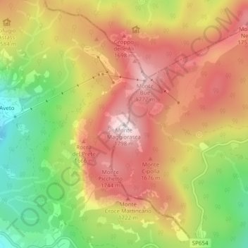
Name: Monte Maggiorasca topographic map, elevation, terrain.
Average elevation: 5,033 ft
Minimum elevation: 3,999 ft
Maximum elevation: 5,879 ft
Make a donation
Gear up for your next adventure:
As an Amazon Associate, this site earns from qualifying purchases at no extra cost to you.