
Garfield topographic map
Click on the map to display elevation.
About this map
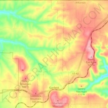
Name: Garfield topographic map, elevation, terrain.
Location: Garfield, Benton County, Arkansas, 72732, United States (36.43656 -94.01112 36.49888 -93.94922)
Average elevation: 1,486 ft
Minimum elevation: 1,201 ft
Maximum elevation: 1,719 ft
Benton County trails, hiking, mountain biking, running and outdoor activities