
Make a donation
Gear up for your next adventure:
As an Amazon Associate, this site earns from qualifying purchases at no extra cost to you.
Rio Curumuri topographic map
Click on the map to display elevation.
Make a donation
Gear up for your next adventure:
As an Amazon Associate, this site earns from qualifying purchases at no extra cost to you.
About this map
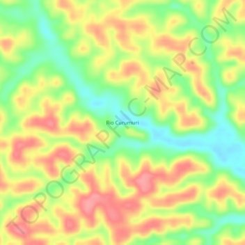
Name: Rio Curumuri topographic map, elevation, terrain.
Average elevation: 161 ft
Minimum elevation: 7 ft
Maximum elevation: 295 ft
Make a donation
Gear up for your next adventure:
As an Amazon Associate, this site earns from qualifying purchases at no extra cost to you.
Other topographic maps
Click on a map to view its topography, its elevation and its terrain.
Amazon
A maior parte do rio está inserida na planície sedimentar Amazônica, embora a nascente em sua totalidade seja acidentada e de grande altitude. Marginalmente, a vegetação ribeirinha é, em sua maioria, exuberante, predominando as florestas equatoriais da Amazônia. A área coberta por água no rio Amazonas…
Average elevation: 20 ft
Make a donation
Gear up for your next adventure:
As an Amazon Associate, this site earns from qualifying purchases at no extra cost to you.