
Make a donation
Gear up for your next adventure:
As an Amazon Associate, this site earns from qualifying purchases at no extra cost to you.
Signal de Botrange topographic map
Click on the map to display elevation.
Make a donation
Gear up for your next adventure:
As an Amazon Associate, this site earns from qualifying purchases at no extra cost to you.
Signal de Botrange
In 1923, the 6-metre (20-foot) Baltia tower was built on the summit to allow visitors to reach an altitude of 700 m (2,300 ft). A stone tower built in 1933/34 by François Fagnoul from Ovifat on the Botrange crowned a steel weather vane with the relieved name SICCO CAMPO until World War II. Meanwhile, the spire serves as transmitter of Radio Contact and reaches a de facto height of 718 m (2,356 ft).
Make a donation
Gear up for your next adventure:
As an Amazon Associate, this site earns from qualifying purchases at no extra cost to you.
About this map
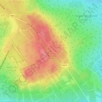
Name: Signal de Botrange topographic map, elevation, terrain.
Average elevation: 2,162 ft
Minimum elevation: 2,028 ft
Maximum elevation: 2,300 ft
Make a donation
Gear up for your next adventure:
As an Amazon Associate, this site earns from qualifying purchases at no extra cost to you.
Other topographic maps
Click on a map to view its topography, its elevation and its terrain.