
Thank you for supporting this site ❤️
Make a donation
Make a donation
Gear up for your next adventure:
As an Amazon Associate, this site earns from qualifying purchases at no extra cost to you.
Champia topographic map
Click on the map to display elevation.
Thank you for supporting this site ❤️
Make a donation
Make a donation
Gear up for your next adventure:
As an Amazon Associate, this site earns from qualifying purchases at no extra cost to you.
About this map
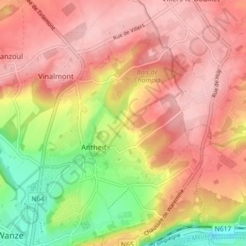
Name: Champia topographic map, elevation, terrain.
Location: Champia, Antheit, Wanze, Hoei, Luik, Wallonië, 4520, België (50.53507 5.22338 50.57507 5.26338)
Average elevation: 489 ft
Minimum elevation: 180 ft
Maximum elevation: 676 ft
Thank you for supporting this site ❤️
Make a donation
Make a donation
Gear up for your next adventure:
As an Amazon Associate, this site earns from qualifying purchases at no extra cost to you.