
Make a donation
Gear up for your next adventure:
As an Amazon Associate, this site earns from qualifying purchases at no extra cost to you.
Honey Grove topographic map
Click on the map to display elevation.
Make a donation
Gear up for your next adventure:
As an Amazon Associate, this site earns from qualifying purchases at no extra cost to you.
Honey Grove
Honey Grove is in central North Texas, in eastern Fannin County, 16 miles (26 km) east of Bonham, the county seat, 39 miles (63 km) north of Greenville, 42 miles (68 km) east of Sherman, and 90 miles (140 km) northeast of the central business district of Dallas. Honey Grove was developed on flat to gently rolling terrain with scattered trees. The city is at an elevation ranging from about 580 to 690 feet (180 to 210 m) above sea level. U.S. Highway 82 and State Highway 56 traverse the city from east to west, and State Roads 34, 100, and 824 run north and south. Bonham is the closest major economic center. Its climate produces an annual average daily maximum temperature of 75.1 °F, and an average annual rainfall is 43.99 inches (1,117 mm). It is also a part of the Texoma region.
Make a donation
Gear up for your next adventure:
As an Amazon Associate, this site earns from qualifying purchases at no extra cost to you.
About this map
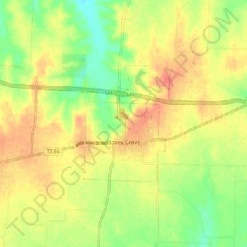
Name: Honey Grove topographic map, elevation, terrain.
Location: Honey Grove, Fannin County, Texas, 75446, United States (33.57186 -95.94192 33.60558 -95.85660)
Average elevation: 640 ft
Minimum elevation: 554 ft
Maximum elevation: 705 ft
Fannin County trails, hiking, mountain biking, running and outdoor activities
Make a donation
Gear up for your next adventure:
As an Amazon Associate, this site earns from qualifying purchases at no extra cost to you.
Other topographic maps
Click on a map to view its topography, its elevation and its terrain.
Make a donation
Gear up for your next adventure:
As an Amazon Associate, this site earns from qualifying purchases at no extra cost to you.
Make a donation
Gear up for your next adventure:
As an Amazon Associate, this site earns from qualifying purchases at no extra cost to you.