Geolocate

Victoria topographic map

Click on the map to display elevation.

About this map

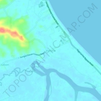
Name: Victoria topographic map, elevation, terrain.

Location: Victoria, Surigao del Sur, Caraga, 8302, Philippines (9.01485 126.18970 9.05485 126.22970)

Average elevation: 20 ft

Minimum elevation: -13 ft

Maximum elevation: 223 ft

Gear up for your next adventure:

🏥Hiking First Aid Kits - Comprehensive medical kits for remote trail injuries
🚁Photography Drones - Capture stunning aerial views of landforms and topography
🖼️Topo Map Wall Art - Decorative topographic prints of famous peaks and regions
🧭GPS Watch Accessories - Bands and chargers for GPS watches
🛰️Handheld GPS Units - Professional satellite navigators for precise backcountry mapping

As an Amazon Associate, this site earns from qualifying purchases at no extra cost to you.