
Thank you for supporting this site ❤️
Make a donation
Make a donation
Gear up for your next adventure:
As an Amazon Associate, this site earns from qualifying purchases at no extra cost to you.
红原县 topographic map
Click on the map to display elevation.
Thank you for supporting this site ❤️
Make a donation
Make a donation
Gear up for your next adventure:
As an Amazon Associate, this site earns from qualifying purchases at no extra cost to you.
About this map
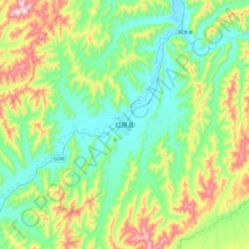
Name: 红原县 topographic map, elevation, terrain.
Location: 红原县, རྔ་བ་རྫོང་ 红原县, 阿坝藏族羌族自治州, Sichuan, China (32.63680 102.38141 32.95680 102.70141)
Average elevation: 12,113 ft
Minimum elevation: 11,388 ft
Maximum elevation: 14,009 ft
Thank you for supporting this site ❤️
Make a donation
Make a donation
Gear up for your next adventure:
As an Amazon Associate, this site earns from qualifying purchases at no extra cost to you.