Geolocate

Mendota topographic map

Click on the map to display elevation.

About this map

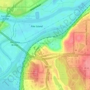
Name: Mendota topographic map, elevation, terrain.

Location: Mendota, Dakota County, Minnesota, 55150, United States (44.87997 -93.16848 44.89331 -93.15136)

Average elevation: 794 ft

Minimum elevation: 686 ft

Maximum elevation: 958 ft

Dakota County trails, hiking, mountain biking, running and outdoor activities

Other topographic maps

Click on a map to view its topography, its elevation and its terrain.

Pickerel Lake

United States > Minnesota > Dakota County > Lilydale

Average elevation: 827 ft

Hastings

United States > Minnesota > Dakota County

Average elevation: 797 ft

Hastings

United States > Minnesota > Dakota County

Average elevation: 797 ft

Coates

United States > Minnesota > Dakota County > Coates > Coates

Average elevation: 919 ft

Empire Lake

United States > Minnesota > Dakota County

Average elevation: 909 ft

Gear up for your next adventure:

🛌Ultralight Sleeping Bags - Compact down bags for cold nights in the wilderness
🎒Hydration Pack - Hands‑free water reservoir for long hikes
🧺Microfiber Travel Towels - Compact and fast-drying towels for trail use
🪑Portable Camp Table - Compact table for campsite meals
🥾Women's Hiking Boots - Top-rated trail boots with ankle support and superior grip

As an Amazon Associate, this site earns from qualifying purchases at no extra cost to you.