
Make a donation
Gear up for your next adventure:
As an Amazon Associate, this site earns from qualifying purchases at no extra cost to you.
Altenwalde topographic map
Click on the map to display elevation.
Make a donation
Gear up for your next adventure:
As an Amazon Associate, this site earns from qualifying purchases at no extra cost to you.
Altenwalde
Das Dorf liegt in Hinterpommern, an der Pilow, südlich des Pielburger Sees, auf einer Anhöhe, etwa 25 Kilometer westlich von Neustettin und drei Kilometer südwestlich von Barwice (Bärwalde).
Make a donation
Gear up for your next adventure:
As an Amazon Associate, this site earns from qualifying purchases at no extra cost to you.
About this map
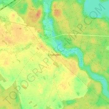
Name: Altenwalde topographic map, elevation, terrain.
Average elevation: 472 ft
Minimum elevation: 404 ft
Maximum elevation: 528 ft
Make a donation
Gear up for your next adventure:
As an Amazon Associate, this site earns from qualifying purchases at no extra cost to you.
Other topographic maps
Click on a map to view its topography, its elevation and its terrain.
Neustettin
Polen > Woiwodschaft Westpommern > powiat szczecinecki
Die Stadt liegt in Hinterpommern, im Zentrum der Draheimer Seenplatte (Pojezierze Drawskie), in einer Höhe von 135 m über dem Meeresniveau, etwa 60 km südsüdöstlich von Köslin (Koszalin) und 140 km ostnordöstlich von Stettin.
Average elevation: 479 ft